Field visits
Delegates chose from a selection of field visits across Northern Ireland and into the Republic of Ireland, exploring different peatland habitats, restoration techniques and approaches to research, monitoring and engagement.
Altikeeragh Bog
Binevenagh and Coastal Lowlands Landscape Partnership Team
Delegates joined the Binevenagh and Coastal Lowlands Landscape Partnership Team for a walk to learn about peatland restoration work on Altikeeragh Bog from source to sea. Participants had the opportunity to learn about the history of Altikeeragh Bog, early restoration attempts in the late 1990s and recent (2020 – present) work to restore the peatland and improve water quality. Monitoring of restoration outcomes is ongoing, and participants had the opportunity to discuss the restoration and monitoring methods employed. Along the way participants heard about the opportunities and challenges with other water quality and outdoor recreation projects being delivered by the Landscape Partnership. Throughout, there were breaks to take in some of the wonderful scenery and historic sites within the Binevenagh Area of Outstanding Natural Beauty.
Altikeeragh Bog is a 180.48ha area of intact blanket bog located in the uplands of Binevenagh AONB, approximately 25 miles from the city of Derry~Londonderry. Owned and managed by Northern Ireland Environment Agency, Altikeeragh Bog Nature Reserve was designated as an Area of Special Scientific Interest (ASSI) in 1999 for notable species such as the hummock-forming Sphagnum imbricatum moss. The site provides habitats for a range of upland birds including snipe, red grouse, and waders as well as many butterflies and Sphagnum mosses. Previously impacted by peat cutting and drainage, it is hoped that conservation and enhancement of this habitat will result in birds such as the hen harrier returning to breed at this site. Cuckoo, meadow pipit, sedge warbler, stonechat, male hen harrier, and grouse have all been spotted at Altikeeragh.
Peatland restoration works over the past 3 years have involved the creation of 155 peat dams and 90 plastic dams at 10m spacing and bunding to control water flow at an eroded area at the entrance to the site. The environmental benefits and outcomes of this project will be monitored in the long-term by Raymond Flynn and his colleagues in the Hydrology Department at Queen’s University Belfast using digital piezometers and dipwells located across the site. In advance of the peatland restoration works, QUB had collected a full year’s data to observe water levels and flows within the bog. This data will be used to compare water levels and flows following the dam creation works and will indicate how successful the work has been in retaining water within the bog, particularly in the drier summer months. Visual inspections of water levels and flows by the Landscape Partnership Scheme team and others within just a few months of the restoration works suggested that the dams installed as part of this project are performing well.
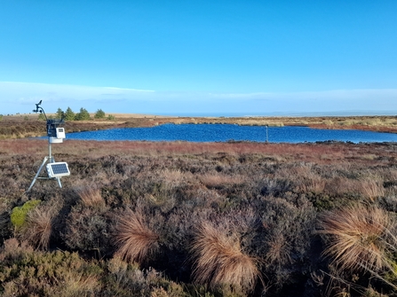
Altikeeragh Bog monitoring. Credit Laura McAuley.
Beaghmore Stone Circles, Haugheys Bog and Black Bog
Department for Communities Historic Environment Division and Ulster Wildlife
Delegates joined the Department for Communities and Ulster Wildlife to discover Northern Ireland’s peatland archaeology and two contrasting raised bogs.
Prehistorian Dr Vicky Ginn (DfC Historic Environment Division) led a tour around Beaghmore Stone Circles which was discovered during peat cutting in the 1940s. The site consists of seven stone circles, eight stone alignments and 12 cairns dating to the Bronze Age and is pre-dated by Neolithic occupation and cultivation. Blanket peat formation started around 400 BC in the locality, and at approximately 80 BC the peat had encroached upon the stone circles eventually covering them entirely. Some of the stone rows align with the mid-winter solstice, while the site also mirrors craters and river channels observable in the moon. The precise function of the site is open to interpretation; however, the site aptly demonstrates the exciting types of archaeology that can be found within Northern Ireland’s peatlands.
Haugheys Bog is a 30ha lowland raised bog that was industrially extracted until approximately 2017. The site was left completely bare and drained, and with forestry surrounding the site, it has been gradually colonised by Sitka spruce. In 2022 Ulster Wildlife and An Creagán purchased the site using DAERA funding, with the aim of developing it as a demonstration and training hub for practitioners, contractors and landowners. Ulster Wildlife would welcome the thoughts and experience of conference delegates to help guide the vision for this site going forward.
Black Bog SAC is one of the best examples of lowland raised bog in Northern Ireland, in the heart of the south Sperrins. Black Bog sits at the head of the Owenreagh River which is one of the last strongholds for the freshwater pearl mussel. Ulster Wildlife have been working with Forest Service Northern Ireland and private landowners to restore degraded habitats using peat dams and bunding around the edge of the site as well as removing invasive species from the open bog since 2023.
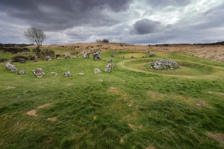
Beaghmore Stone Circles. © Crown DfC Historic Environment Division
Bencroy blanket bog
National Parks and Wildlife Service and WaterLANDS
Bencroy is a blanket bog located in the Cuilcagh-Anierin Uplands Special Area of Conservation in the Republic of Ireland. This blanket bog is facing several problems such as extensive erosion, natural/artificial drainage and invasive species colonisation coming from nearby forestry plantations. Under WaterLANDS, a Horizon 2020 project under the Green Deal, NPWS are aiming to restore over 100 ha of blanket bog using a range of techniques such as geotextiles and coir logs to reduce carbon loss and increase vegetation cover, and leaky timber and stone dams, to reduce the water flow across the site. In addition to the restoration actions, the team also has developed an extensive monitoring programme across the SAC, with several actions at Bencroy to measure the efficacy of the restoration actions in regard to water levels, water quality and carbon balance. During this visit delegates explored (1) the different restoration actions to address complex erosion on blanket bogs and (2) how to implement a monitoring programme to assess the efficacy of restoration actions.
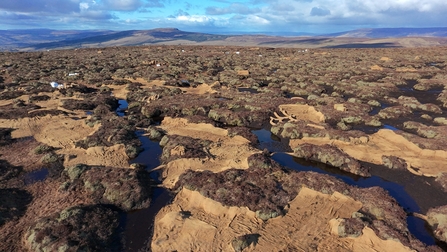
Drone footage of restoration on Bencroy. Credit: Guaduneth Chico.
CAFRE Hill Farm Centre
College of Agriculture, Food and Rural Enterprise
The CAFRE (College of Agriculture, Food and Rural Enterprise) Hill Farm Centre is situated at Glenwherry on the southern end of the Antrim Hills and is home to 1000 breeding ewes and 100 suckler cows along with a vast range of birds and wildlife. The CAFRE Hill Farm Centre consists of 960 hectares, is the only publicly owned hill farm on the island of Ireland and has been in ownership of the Department of Agriculture, Environment and Rural Affairs (DAERA) since 1963.
In 2009, the Glenwherry Hill Regeneration Partnership (GHRP) was established to focus on improving the habitats to encourage birds and wildlife to nest, rest or forage on the hill farm whilst maintaining a productive upland livestock enterprise. Since the establishment of GHRP, CAFRE have undertaken a range of projects to help improve the habitat quality and quantity to encourage birds and other species to nest, rest or forage there, to improve water quality for a nearby water treatment plant, to provide flood resilience, to increase carbon storage and sequestration and prevent wildfires.
The site visit included seeing the recently restored Forest to Bog site and the Water Table Depth project. In addition the visit included an update on the research projects that are being carried out on the farm and the breeding wader site which is being managed with grazing livestock to encourage the nesting of breeding waders.
The visit was led by CAFRE’s Senior Biodiversity Technologist Nicola Warden and Senior Livestock Technologist Eileen McCloskey. Along the tour, the group heard from Professor Phil Jordan from Ulster University about the research work that is ongoing across the peatland areas.
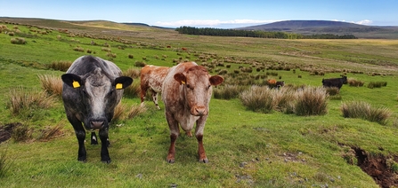
CAFRE Hill Farm. Credit: Nicola Warden
Divis and Black Mountain
National Trust
The National Trust Divis and the Black Mountain property is located within the Belfast Hills, and overlooks the city of Belfast. Divis Mountain rises to 478m above mean sea level and is the highest peak within the Belfast Hills. The site is approximately 793ha, and comprises a mosaic of upland habitats, namely: Upland Heath, Purple Moor Grass and Rush Pasture, Blanket Bog, and Acid Grasslands. The site hosts the headwaters of four rivers; three flow towards Belfast and drain into Belfast Lough (showcasing Source to Sea). Alongside managing for nature, National Trust provide access, making this an important public amenity site on the edge of Belfast.
Blanket Bog (~130ha) has been heavily impacted by artificial drainage and overgrazing in the past. Since 2021, RPS and Queens University Belfast have been undertaking hydrological research onsite, this has included groundwater (piezometers installed in clusters across the peatlands onsite), runoff (assessed through flumes installed across the site), and water quality monitoring which has been linked with weather data collected onsite. Additional monitoring has included a condition assessment of the habitats onsite, and the installation of Eyes on the Bog; peatland monitoring onsite aligns with the National Trust’s Peatland Monitoring Approach.
The monitoring undertaken onsite informs the current peatland restoration plan. The first phase of peatland restoration began in September 2025. Restoration in phase 1, will target gentle slopes (<10.5%) and include peat and timber dams, and zipper infilling, along approximately 25km of drains which have been identified during monitoring. Phase 2 of restoration will be informed by ongoing monitoring throughout phase 1, but is anticipated to target remaining drains onsite, and those areas with a slope >10.5%.
To facilitate restoration onsite and to address the issue of overgrazing, the stocking rate has been reduced. The grazing livestock will now be wearing virtual fencing collars; NoFence collars. The use of NoFence collars onsite allows for target grazing of habitats, and the exclusion of grazing from blanket bog undergoing restoration, and other areas of peat which may be impacted by poaching.
Baseline Hydrological and Ecological monitoring has informed contemporary management of the habitats, particularly the peatland habitats on Divis and the Black Mountain. We anticipate that restoration work will raise the water table, increase carbon storage of the peatlands and increase the biodiversity and quality of habitats. We will continue to monitor alongside restoration, to track progress.
The field visit to Divis & Black Mountain provided an opportunity to understand how monitoring has informed our habitat restoration programme. There were contractors on site blocking drains, so delegates got to see active peat restoration works. They discovered the challenges and opportunities of upland site management and how we aim to manage for people, nature, water and carbon.
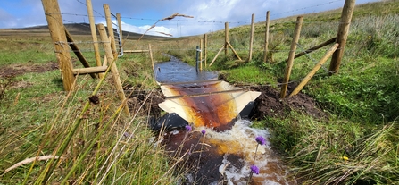
Flume installation on Divis Mountain. Credit: Andrew Corkhill.
Garron Plateau
IUCN UK Peatland Programme and Northern Ireland Environment Agency
This fieldtrip visited the Garron plateau, an area with a diverse mosaic of peatland habitat and home to a number of nationally rare species including bog orchid and marsh saxifrage. The purpose of this trip was to consider the peatland mosaic and the importance of boundary and transition habitats to the broad habitat function and health. It supported practitioners looking at how to include the wider mosaic into their work and those interested in broadening their understanding of peatland ecology.
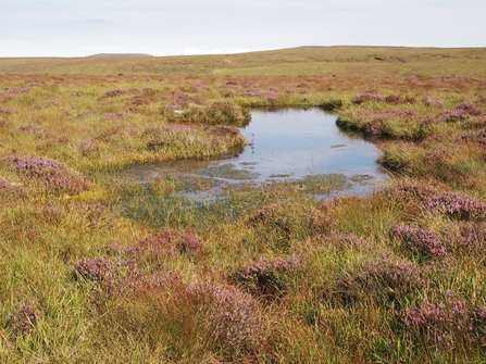
Garron Plateau. Credit: Bobbie Hamill.
Glenveagh National Park
National Parks and Wildlife Service (NPWS)
Delegates enjoyed an 8km walk through Glenveagh National Park with the National Parks and Wildlife Service staff. The field visit started on the watershed at the head of Glen Veagh where heavily eroded blanket bog opened the conversation on the historic legacy of peat-based landscapes. There was also an introduction to on-site research linking erosion in peat-based plateau environments and grazing activity. This led into discussions regarding upland blanket bog restoration options, specifically addressing peat hags and drainage networks on steep slopes. Mitigation of downstream effects on species such as Salmon and Fresh Water Pearl Mussel is also a consideration at this site. Moving down into the valley proper, the park’s ongoing efforts to reforest 1000ha of native woodland on the valley sides were demonstrated. Deer management methods on blanket bog and associated habitats were discussed, as well as the topic of climate change and woodland expansion into Annex I peat-based habitats within Natura 2000 sites.
The field trip also passed a raised bog at the head of the Lough where discussions focused on basic restoration options for degraded cutover areas. The final leg of the walk was through ancient oak woodland where deer management and invasive species control were the subject matter.
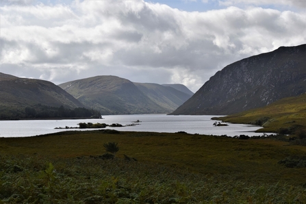
Glenveagh National Park. Credit: National Parks and Wildlife Service
Lough Bradan
Northern Ireland Water ‘forest to bog’ restoration
Lough Bradan catchment is located 19km west of Omagh. The Lough Bradan direct catchment (355 Ha) is entirely owned by NI Water, and the Lough acts as an impounding reservoir providing 7.2Ml/day of drinking water for nearby towns and villages via our water treatment works. The area is leased by NI Water to Forest Service under a 150-year agreement (67 years in) and is currently covered mainly with coniferous forestry planted on degraded peat bog.
In 2021 NI Water restored 27 Ha of previously forested land directly around the reservoir using cell bunding and drain blocking. In 2023 we began planning additional restoration works in some recently felled compartments beside the lough. The design included a variety of techniques including contoured cell bunding, drain blocking and remedial works in the 2021 restoration area. A restoration plan was designed by Dr Hugh Cushnan of RPS and in October 2024 we appointed William O’Kane’s as our engineering contractor. Restoration work began in December 2024 and finished in February 2025.
Delegates joined a guided walk to the different areas of restoration and discussed the results of on-site hydrological monitoring.
Aerial view of Lough Bradan restoration area. Credit: NI Water.
Seamus Heaney HomePlace, Open Ground tour and Sluggan Bog
Seamus Heaney HomePlace and Bulrush Horticulture
This visit celebrated the life and works of Nobel laureate Seamus Heaney, an Irish poet, playwright and translator who used his famous bog-poems to support peatland conservation and explore the relationships between people, place and identity. HomePlace is at the heart of the area that inspired so much of the poet’s work, situated between Heaney’s two childhood homes at Mossbawn and The Wood, and only a few hundred yards from St Mary’s Church, Bellaghy, which he chose as his final resting place.
Delegates joined Education Officer Angeline Kelly for a creative writing workshop exploring bog bodies and how our past and present interact, an important theme in Heaney’s writing. They also visited the Strand at Lough Beg and the Lough Neagh eel fishery, both of which feature in Heaney’s poetry.
The day also included a visit to Sluggan moss, an active peat extraction site since the 1980s. In 2012, the landowner gave permission for Bulrush Horticulture to restore part of the site, with restoration work starting that year. Over a number of years, the area was reprofiled and a series of cascading microbunds constructed to control water levels. These rewetted bunded areas were then seeded with various Sphagnum mosses and bog cotton. The top of the bunds were seeded with a mixture of heathers and purple moor grass. Water levels and species colonisation were monitored and corrective action or further seeding carried out as needed. Queen’s University PhD student Juliet Everson is preparing her thesis comparing the restored site with other designated areas of peatland in the North of Ireland.
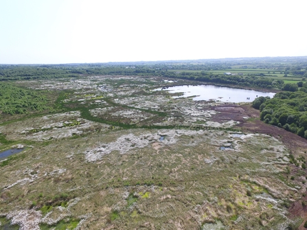
Sluggan Bog. Credit: Bulrush Horticulture.
Springwell Farm
RSPB
Within the Antrim Hills lies 100 hectares of Blanket Bog and other associated habitats which form part of Springwell Farm. This privately owned area, partly within the Garron Plateau SAC, represents a broad range of challenges and opportunities for restoration, which RSPB have been working on in partnership with the owner for the last couple of years. It is adjacent to RSPB NI’s long term partnership with NI Water at Garron Plateau.
This site has seen damage historically from drainage, erosion, fire, and peat extraction by hand and by machine. There is also a Molinia issue here, as well as a small plantation of former Christmas trees. The site is currently grazed according to prescriptions in DAERA’s Environmental Farming Scheme (EFS), and it is within RSPB NI’s Group Option for that scheme within the Garron Plateau area.
RSPB NI has secured grant funding from DAERA through NIEA and the Shared Island Initiative’s Peatland Challenge Fund to kickstart the restoration of this site. Longer term, it is aligned and registered with the Peatland Code, and conversations on this site visit with RSPB NI and the landowner included discussion around recognition of the multiple benefits of sites like this and the support networks which may be needed to enable these sites to thrive in the years ahead.
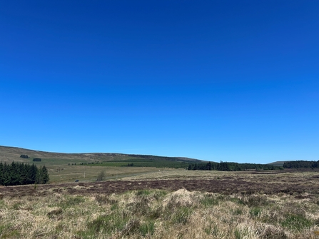
Springwell Farm RSPB. Credit: Lauren O'Donnell.
Tattinafree Bog
RSPB
Tattinafree Bog is one of over ten raised bogs nestled within the 1,000-hectare Colebrooke Estate in County Fermanagh. Set in a landscape of inter-drumlin hollows, the estate is a rich mosaic of lowland raised bogs, farmland, and woodland. The RSPB is currently developing a comprehensive restoration plan for all ten bogs as part of a Peatland Code project cluster.
Historically, Tattinafree, like the other bogs on the estate, has suffered from drainage and turf cutting, both by hand and machine. These past interventions have led to habitat degradation and significant greenhouse gas emissions. The restoration project aims to reverse this damage through techniques such as drain blocking, reprofiling eroded peat surfaces, and rewetting degraded areas.
Delegates joined a guided visit where the RSPB shared their restoration approach and delved into the unique challenges Irish raised bogs face. They had the chance to see areas once used for hand-cut turf to heat local homes, machine cut areas, and some areas where peat has been excavated down to the mineral layer. Some sections have naturally filled with water, forming stunning shallow pools, while others have been overtaken by trees or afforested with conifers. The bog’s edge is tightly bounded by intensive agriculture, a common scenario in Ireland, which adds complexity to restoration efforts, particularly where drain-blocking is needed.
Despite these pressures, Tattinafree remains a striking example of a raised bog ecosystem. In places, over 10 metres of peat still persist, supporting vibrant Sphagnum mosses, Greater Sundew, Large Heath butterflies, Green Hairstreaks, and a kaleidoscope of dragonflies and damselflies. This site visit offered the opportunity to witness the resilience of peatland habitats and see how targeted restoration can bring them back to life.
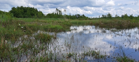
Tattinafree Bog. Credit: Maria Mulholland.
